Devpost
Participate in our public hackathons
Devpost for Teams
Access your company's private hackathons
Grow your developer ecosystem and promote your platform
Drive innovation, collaboration, and retention within your organization
By use case
Blog
Insights into hackathon planning and participation
Customer stories
Inspiration from peers and other industry leaders
Planning guides
Best practices for planning online and in-person hackathons
Webinars & events
Upcoming events and on-demand recordings
Help desk
Common questions and support documentation
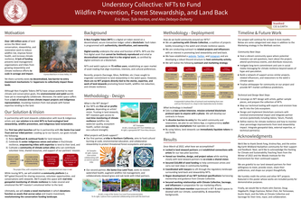
We’re minting NFTs to accelerate significant & continual funding for ecological land stewardship and indigenous land reclamation.
Understanding health damages is critical to align government incentive to spend on fire prevention & health adaptation. My model calculates damage costs in an easy, scalable, & repeatable way.
Combining data on 2019 power shutoffs, wildfires, and probabilistic fire simulations we evaluate the tradeoffs between the economic impact of this mitigation strategy and the fire it seeks to prevent.
Using satellite data to determine where in Australia wildfires pose the most risk. The project can be further built on to determine risk in other areas and further improve accuracy.
Our two part project aims to combine the technological and social solutions necessary to deal with increased wildfires in poorly resourced areas.
Given the temperature and deformation at sensor locations, the physics-informed machine learning framework predicts the temperature and deformation everywhere in the structure!
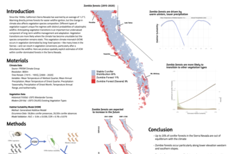
Many California forests aren't expected to regenerate after disturbances, with implications for long-term fire management.
Given how crucial tree canopy height data is in accurately quantifying carbon stock within forests, we aim to build a machine learning model that predicts canopy height using only 2D satellite images.
As wildfires pose a growing threat worldwide, early fire detection is critical. We leverage Transformers and other deep learning models to detect wildfire presence from aerial images taken by drones.
Assessing the Change in Debris Flow Risk Due to Wildfires Using Topological Features
1 – 10 of 10